Description
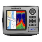
Full – color Lowrance HDS – 5i Fishfinder / GPS Chartplotter with StructureScan Sonar Imaging Bundle. Presenting BIG color definition and multi-function performance in a boatspace-saving design! See all the action in second-to-none clarity on an exclusive high-resolution 5″ SolarMAX color display. Of course a sonar-enhancing broadband sounder and 16-channel GPS are built-in to help you on your way, not to mention pre-loaded Lake Insight Maps for U.S. inland and Great Lakes coverage. It’s compatible with Navionics chartcards, too, so you can add more maps at any time. Now featuring StructureScan technology for a complete picture that’s unmatched in fishfinding! With years of developing and testing, StructureScan reveals every nook and cranny, removing all guesswork so you spend more productive time fishing, with the greatest clarity, highest detail and brightest viewing possible. Display: 5″ 480 x 480 16-bit color SolarMAX display for surprisingly crisp, clear views; Backlit screen and keypad for easy use in bright sunlight or dark conditions; Split-screen presentation capable; Provides GPS and sonar overlay data. Sonar: Dual-frequency Skimmer 83 / 200 kHz transducer; Max 250W peak-to-peak (31W RMS) actual; 30,000W peak-to-peak analog equivalent; HyperScroll feature locates and displays fish targets at higher boat speeds with increased soundings per second; FasTrack feature displays flasher-style sonar returns in a narrow vertical column at the far right of the sonar screen. Especially useful for ice fishing or fishing at anchor; FlashGraf feature combines a scrolling sonar target graph with a digital LCD flasher… two of the most popular ways of finding fish all in one screen; Temperature display.; GPS / Navigation: Internal, high-sensitivity GPS+WAAS antenna; Includes Lake Insight Map Bundle for U.S. Inland and Great Lakes coverage; 16 channels; Stores up to 5,000 waypoints, 200 routes, and up to 10 trails; Navionics chartcard compatible (not included).; More: Sea
Built-in broadband sounder
Internal 16-channel GPS+WAAS antenna
5″/12.7 cm SolarMAX™ Plus display
Built-in high-definition Insight™ mapping options
Large selection of chartcard options including Navionics® Platinum+ with TurboView™
[amz_corss_sell asin=”B003DU44VU”]